Updated 1/7/18:
Radar looks o.k. to me. Ride is on. Only change is I will be starting at the Weston Bluffs Trail head and lot City Hall as posted below. Parking should not be a problem - only diehard gravel grinders will be out. If you are one join in today.
Route sheet has been added below along with course maps (Garmin)
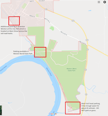
Parking update: Weston Bend State Park (
16600 Missouri 45, Weston, MO 64098) is open and will remain open this week unless we have snows/freezing rain. As mentioned below, there is parking for about 25 to 30 vehicles at the main South Weston Bluffs Trail head. I am parking at the North end of the trail (Weston City Hall) and riding South to the Start of anyone wants to join - see below.
Weather: We are keeping an eye on the forecast. Usually we ride regardless of the weather unless the road conditions are dangerous at which time we would postpone the event for another day. I will post an update on Saturday if anything changes. As of now, we are a GO.
What: Bean Lake Gravel Challenge
When: Sunday January 7, 2018, 10:00 am
Where: Weston, MO -
Why: Come enjoy a scenic and challenging ride to one of the few remaining marshes left in the Missouri River Floodplain.
Meet at the Weston Bluffs Trail head for our 10:00 am start time.
NOTE: the main trail head only has room for about 25 vehicles. If that lot fills up, please park in downtown Weston City Hall or the Weston Bend State Park - see map. Ride South on Weston Bluffs Trail to the start (only a couple miles) or just wait for the main group heading North.
As of now I plan to park at the Weston City Hall and lead a group from the Weston City Hall back South along the route to the Weston Bluffs Trail head. For those who want to add some miles or enjoy a scenic warmup along the trail please join me at 9:30 am to depart South to meet up for the planned 10:00 am start.
Facilities are available in the City of Weston for those whom need To Go... No facilities are available at the Weston Bluffs Trail head
A little history on Bean Lake...Bean Lake in a section of the Little
Bean Marsh Conservation Area. The 400 acre oxbow is home to migrating
waterfowl and shorebirds during spring and fall. Amazingly, more than
130 species of birds have been seen here though the number of birds
depends on the water level. There is half a mile of disabled accessible
trail that is perfect for hiking with families and friends. This leads
to a viewing platform over the freshwater marsh. Another 200 yard trail
leads to a viewing blind overlooking Cottonwood Slough.
Course Map(s)
Route Sheet -
Bean Lake Gravel Challenge Route Sheet
Beside the loop around Bean Lake this is an out/back course which will make it perfect for anyone who does not want to ride the entire distance.
Link to Garmin route:
https://connect.garmin.com/modern/course/16981438
Do to several request we have made short course(s). One that stays flat and one that includes some hills and is longer.
Link to Short Course route:
https://connect.garmin.com/modern/course/17075609
Link to Short Course w/hills route:
https://connect.garmin.com/modern/course/17075712
Disclaimer for the Bean Lake Gravel Challenge:
You are 100%
responsible for yourself! You are totally on your own. There are no
rider services. There is no support. If you choose to participate, you
agree to taking full responsibility for what happens to you out on the
course. Please have someone you can call to come get you in the case of
emergency, fatigue, freezing weather or bike failure.


